The valley Dørdalen

- Details
- Category: Turer
- Published on 30 November -0001
- Hits: 17165
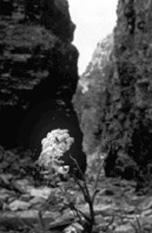
General informationThe Dørdalen is one of the side valleys, which end into the Våla River with outlet by the Våla Bridge. The valley is recognised to be the largest canyon of the Gudbrandsdal. It forms a deep gap in the landscape, and much of the valley has conifer forest, which to some content is like to primeval forest. But this is a cultivated landscape that the village people in many hundred years have used and marked. The route goes along the river in partial rough terrain, which requires good shoes and condition.
Length: 8 km |
 Dørdalen Dørdalen |
ThemesThe landscape and nature are very rare for the fact that this is in Gudbrandsdalen. Here there are precipitous mountain sides 2-300 meters up to the mountain plateaus. Here is untouched nature and a vigorous flora. Hay harvest land.Here there are 300 years old traditions in hay harvest, from which we still can see traces. Catch.The area is an Eldorado for deer animals, which again lure the large predators in the valley. We see hunt houses and catch traps in Døråmot and Kvanndalstunga. |
 Bjønnbua Bjønnbua |
Botanic.The flower “M.a. Fjellkvann” (Angelica) is a characteristic plant in the valley, which gave name to Kvanndal. This is traditionally a cultivated plant used as medicine and in food preparation Legends.In so dramatic landscapes there also have been dramatic incidents. How many of them that are real and fictitious, is hard to know today. |
 Fjellkvann Fjellkvann |